File:Regionmap1.jpg: Difference between revisions
From Perplex City Wiki
Jump to navigationJump to search
No edit summary |
No edit summary |
||
| Line 1: | Line 1: | ||
# [[Perplex City]] | # [[Perplex City]] | ||
# [[Rudon Forest]] | # [[Rudon Forest]] | ||
# [[ | # [[Quagendiep Wetlands]] | ||
# [[Lancewood]] ? | # [[Lancewood]] ? | ||
# [[Newguard]] town | # [[Newguard]] town | ||
Revision as of 18:14, 7 May 2007
- Perplex City
- Rudon Forest
- Quagendiep Wetlands
- Lancewood ?
- Newguard town
- Village in the middle of nowhere
- Black Fork river
- Fivebridge
- Remton
- Village NW of Remton
- Village SW of Fivebridge
- Village SE of Fivebridge
- Vastage
- Vastage Inlet
- Valley near Vastage
- Taranga mountains
- Viendenbourg
- Gladstone
- Wooster
- Village on Black Fork river
- Elmness
- White Fork river
- Meadowtown
- Cuprumton
- Village on Great Penninsula
- Farmland NW of Ryefield - Newguard Plain
- Hills
- Mazyford
- Treachery
- Peterfitch
- Stone Mills
- ?
- ?
- Another bay enclosed by Great Penninsula
- Drowsington and another village on the North Bay
- A Village on the North Bay
- ?
- Town on the Great Penninsula
- Alchemy Bay
- ?
Also, a railway line has #50.
File history
Click on a date/time to view the file as it appeared at that time.
| Date/Time | Thumbnail | Dimensions | User | Comment | |
|---|---|---|---|---|---|
| current | 14:57, 3 March 2007 | 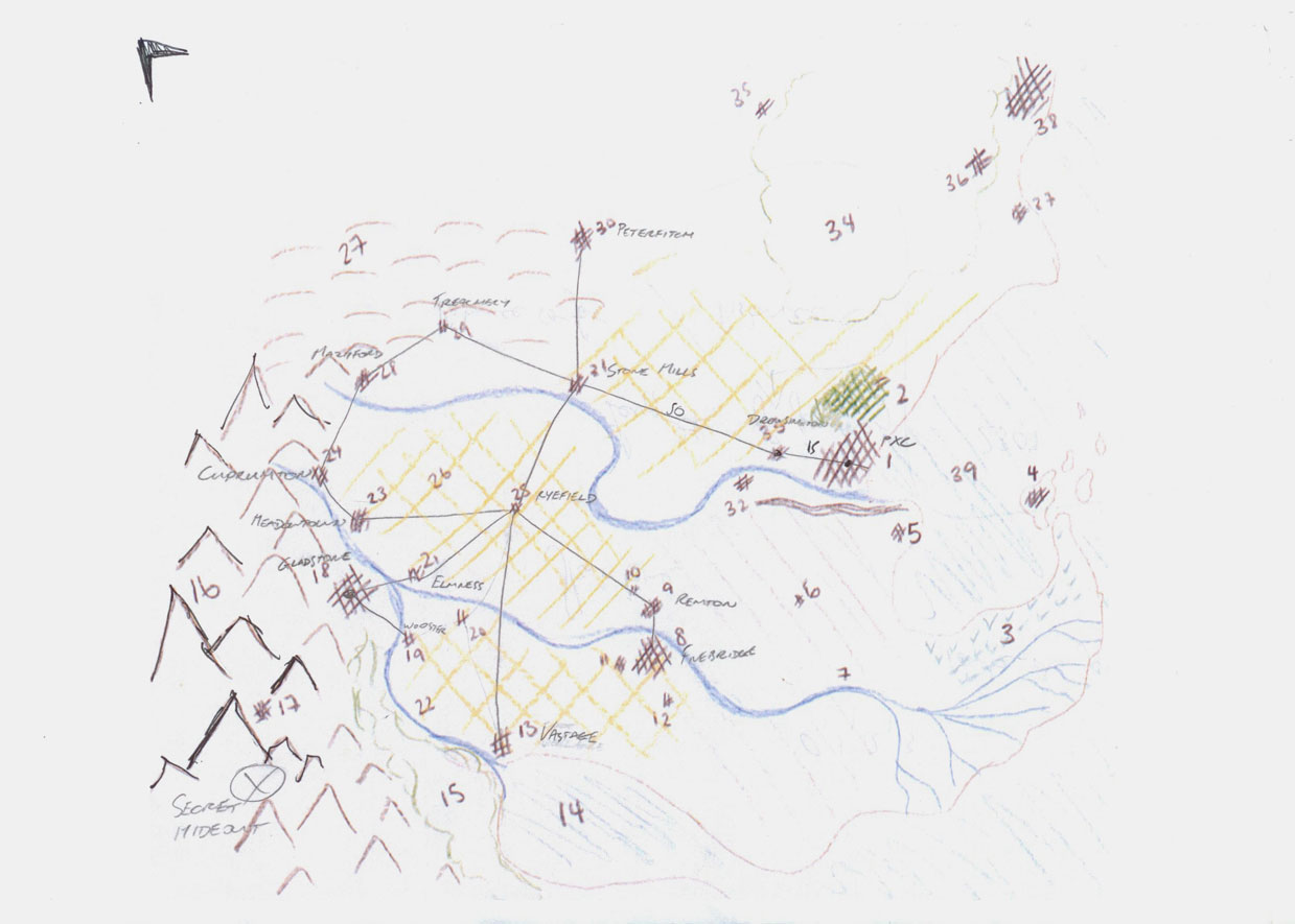 | 1,239 × 885 (104 KB) | Quentin (talk | contribs) |
You cannot overwrite this file.
File usage
The following page uses this file: