Maps: Difference between revisions
From Perplex City Wiki
Jump to navigationJump to search
m ((an edit so i don't fForget to do it . . .)) |
No edit summary |
||
| Line 1: | Line 1: | ||
The definitive map of [[Perplex City]] is, without question, at http://www.perplexcitymap.com - but we have other maps as well. | |||
==Perplex City== | |||
<gallery> | |||
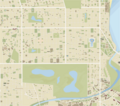
Image:Aeromap.png|The City | |||
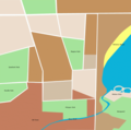
Image:PerplexCityGeneralMap.png|General map of the city | |||
Image:Grid.jpg|The police grid at a heightened state | |||
</gallery> | |||
==Vicinity== | |||
<gallery> | |||
Image:Hikemap.jpg|[[Scarlett]]'s sketched map of the area around [[Viendenbourg]] | |||
Image:PerplexCityRegion.png|the outlying towns and surrounding area | |||
</gallery> | |||
==Neighboring Towns== | |||
<gallery> | |||
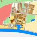
Image:Drowsingtonmap-manageable.jpg|[[Drowsington]] | |||
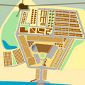
Image:StoneMills-manageable.jpg|[[Stone Mills]] | |||
</gallery> | |||
Revision as of 17:24, 13 September 2006
The definitive map of Perplex City is, without question, at http://www.perplexcitymap.com - but we have other maps as well.
Perplex City
Vicinity
Scarlett's sketched map of the area around Viendenbourg


