Maps: Difference between revisions
From Perplex City Wiki
Jump to navigationJump to search
No edit summary |
No edit summary |
||
| (2 intermediate revisions by the same user not shown) | |||
| Line 3: | Line 3: | ||
==Perplex City== | ==Perplex City== | ||
<gallery> | <gallery> | ||
Image:Aeromap.png|The City | Image:Aeromap.png|The City from above | ||
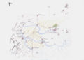
Image:PerplexCityGeneralMap.png|General | Image:PerplexCityGeneralMap.png|General layout of the city | ||
Image:Grid.jpg|The police grid at a heightened state | Image:Subway_map.jpg|The city's [[subway]] system | ||
Image:Grid.jpg|The [[police]] grid at a heightened state | |||
</gallery> | </gallery> | ||
| Line 11: | Line 12: | ||
==Vicinity== | ==Vicinity== | ||
<gallery> | <gallery> | ||
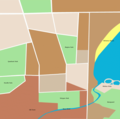
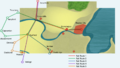
Image:Regionmap1.jpg|A behind the scenes map, from [[Mind Candy]] | |||
Image:Hikemap.jpg|[[Scarlett]]'s sketched map of the area around [[Viendenbourg]] | Image:Hikemap.jpg|[[Scarlett]]'s sketched map of the area around [[Viendenbourg]] | ||
Image:PerplexCityRegion.png|the outlying towns and surrounding area | Image:PerplexCityRegion.png|the outlying towns and surrounding area | ||
| Line 21: | Line 23: | ||
Image:StoneMills-manageable.jpg|[[Stone Mills]] | Image:StoneMills-manageable.jpg|[[Stone Mills]] | ||
</gallery> | </gallery> | ||
==Regions within [[Perplex City]] by name== | |||
*[[Alchemy Bay]] | |||
*[[Artist's Quarter]] | |||
*[[Ascendancy Point]] | |||
*[[Mobius Strip]] | |||
*[[Northside Nature Preserve]] | |||
*[[Old Town]] | |||
*[[Parks]] | |||
*[[Perplex City Zoo]] | |||
*[[Catbite]] | |||
*[[Catacombs]] | |||
*[[Mazy River]] | |||
*[[Newguard settlement]] | |||
Latest revision as of 06:20, 3 April 2007
The definitive map of Perplex City is, without question, at http://www.perplexcitymap.com - but we have other maps as well.
Perplex City
The City from above
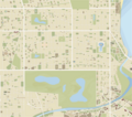
General layout of the city
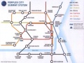
The city's subway system
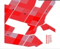
The police grid at a heightened state


Vicinity
A behind the scenes map, from Mind Candy
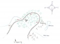
Scarlett's sketched map of the area around Viendenbourg
the outlying towns and surrounding area


Neighboring Towns

